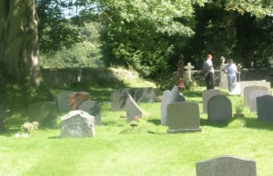
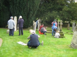
The Project arranged to survey the churchyard at St. David’s church, Heyope as an opportunity to practice careful recording of archaeological materials etc. This is hoped to provide a group of trained volunteers for an eventual survey of Knucklas Castle. The report is now available from Liz Jackson (contact 01547 520182) on CD (or on paper for an additional charge).
The report does not include the details of each grave, but the grave details are also included separately on the CD. This grave information is available now on the church web site (click here) where there is a list of all the graves with their inscriptions etc., and with a map of the graves with links to the grave details.
Here are the cover and contents pages to show the scope:
KNUCKLAS CASTLE COMMUNITY LAND PROJECT
Archaeology and Local History Group
Report on the Churchyard Survey
at St David’s, Heyope
2009 – 2012
A COMMUNITY PROJECT CARRIED OUT BY LOCAL VOLUNTEERS
with the support of Beguildy Community Council
and The Heyope Recreation Ground Trust
Contents
Introduction
The KCCLP 4
Aims of the Survey 4
Involving the community 4
The Survey
Description of the churchyard at St David’s, Heyope 6
Document search 13
The churchyard plan 16
Preparations for recording the monuments 18
Method of recording 19
Recording Days 19
Other memorial features in the churchyard 27
Analysis and summary of results 34
Digitization and publication 44
The Future 44
Acknowledgements 45
Appendices 46
Cover photograph: Heyope churchyard on the day of the EDM survey
Report written and compiled by Elizabeth Jackson and Isabel Forbath with a contribution from Peter North
Photographs by Laura Woodside-Jones
(c) Knucklas Castle Community Land Project Ltd., 1 Heyope Road, Knucklas, Knighton, Powys, LD7 1PT
(c) Accompanying Churchyard Plan: Clwyd-Powys Archaeological Trust
2013 All Rights Reserved
Volunteers working in the S. W. Quadrant, 10th October, 2009


